
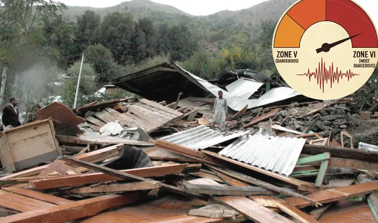


We are literally sitting on a shaky ground! Don’t panic, but it is a reality. The upgrading of the Himalayan region of Jammu and Kashmir from Seismic Zone V to highest risk Zone VI must set alarm bells ringing.
Surrounded by mountains, J&K has been witnessing frequent earthquakes. Who can forget October 8, 2005 when a powerful 7.6 magnitude earthquake rattled the region, claiming thousands of lives and causing massive destruction to structures.
A new study links tectonic tearing under the Tibetan Plateau with rising seismic stress across the Himalayas including J&K. The study ‘The Indian Plate subducting below the Tibet Plateau is tearing apart,’ and is authored by Lin Liu, Danian Shi, and Simon L Klempere.
In J&K, located west of the tear (around 74-77°E), the under-plating process described in the study exacerbates concerns of high-intensity earthquakes. J&K falls under Seismic Zone V, the highest risk category in India’s earlier seismic zoning map. The updated 2025 National Seismic Hazard Map by the Bureau of Indian Standards has elevated the entire Himalayan arc, including J&K, to the newly-created Zone VI.
The study reveals that an “orogen-perpendicular tearing” of the Indian plate along a north-south boundary at approximately 90-92°E longitude; West of 90°E, the Indian lithosphere underplates the Tibetan crust intact, extending about 100 km north of the Yarlung-Zangbo suture.
The orogen-perpendicular tearing is a tectonic process where the Indian Plate, while subducting beneath the Tibetan Plateau, splits along the north-south boundary and perpendicular to the mountain range. This causes the lithosphere mantle to delaminate and sink into the mantle, while the crust remains intact.
The new zone classification indicates a peak ground acceleration (PGA) potentially exceeding 0.36g. PGA is the maximum acceleration experienced by the ground during an earthquake, measured in gravitational acceleration (g). It is the key indicator of seismic hazard assessment and a predictor of structural damage.
PGA values up to 0.5g or higher have also been calculated for the region, as identified in a 2025 Frontiers study on Himalayan tunnels. This translates into a significant risk of magnitude 8.0 or more earthquakes.
Active faults like the Main Himalayan Thrust and Main Boundary Thrust, together with the peculiar terrain of the area and glacial instability, add to the hazard risk. The geological and tectonic settings in Himalayan ranges trigger intense tectonic activity affecting the Kashmir basin in North-West Himalaya. At these places, Indian and Eurasian plates collide creating massive mechanical stress which gets released in the form of earthquakes.
The fresh study brings to the spotlight a comprehensive study by prominent United States-based seismologist Roger Bilham— warning that the Kashmir valley could have an earthquake of largest ever magnitude 9. However, he has not specified any timeframe.
Bilham’s study warns that magnitude 9 earthquakes can trigger landslides that would dam the Jhelum River and cause extensive floods in the valley and subsequent destruction.
Based on his Global Positioning System (GPS) data readings, Bilham had detected high movement of rocks in the Zanskar Mountains north of the Kashmir Valley. This, he stated, means that the zone is likely to rupture when a quake eventually happens; could be nearly 200-kilometres wide. The zone would encompass the Kashmir Valley including the city of Srinagar, home to 1.5 million people.
Bilham who visited Kashmir in 2007, has long ago detected that the Indian plate is slowly burrowing under the Tibetan plateau. He reveals that studies on where the relative movement of the Tibetan plateau was slowest indicate where compression is building up, and a rupture is eventually likely to occur. “I expected this to be in the Pir Panchal range, to the south of the Kashmir valley, but instead, it was in the Zanskar range to the north.”
Bilham has warned that “if slippage occurs over a length of 300 kilometres, as is possible, a mega-quake of magnitude 9 is the likely result. Given building codes and population in the region that could mean a death toll of 300,000 people.”
What makes these studies important is that there has been an increase in high tectonic activities in various areas of J&K particularly Pir Panchal region and Chenab Valley. What makes Kashmir valley more vulnerable is that it embodies a typical geomorphological and active tectonic setup with landforms produced or modified by active tectonic processes with distinct surface expressions. Numerous active faults have been identified in Kashmir with the help of remote sensing techniques validated by morphometric and geomorphological investigations.
In this scenario what can the government and people do? We need to understand that earthquakes can strike anytime and there is no mechanism or technology to prevent it. We can only take measures to minimise loss of lives of property by desisting from constructions in eco-fragile areas.
We forget how most of the houses constructed on centuries-old Dhajji-Diwari system, especially in Kashmir have survived earthquakes. These houses, constructed with wood, bricks and mud mortar, are considered quake-resistant due to its flexibility.
There is a need to undertake micro-seismic zoning and prepare comprehensive disaster management plans to be executed during earthquakes. There is no need to panic during earthquakes but we need to be psychologically and physically prepared! We need to understand that earthquakes comprise a natural phenomenon. We must learn to live with earthquakes and build earthquake resilient societies.
Author is Executive Editor,
Greater Kashmir